Drones take flight in the oil sands
By Matt Powell, Assistant Editor
Industry Innovation & Technology Energy Manufacturing Resource Sector aerospace drones energy manufacturing monitoring TechnologyFLIR and ING robotic aviation take aerial infrared detection west
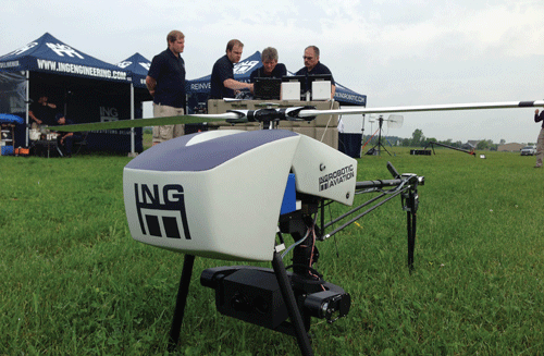
ING Robotics says its Responder unmanned aerial vehicles are becoming popular with industrial customers. PHOTO: ING ROBOTIC AVIATION
Unmanned aerial vehicles (UAVs), or drones (their much cooler connotation), are no longer restricted to the imaginations of science fiction writers and combat movies. For instance, it’s common to find one swooping through the sky for films, commercials and videos as a handy, low-cost alternative to jib cranes or even helicopters.
But they’re also making a foray into the industrial world. A partnership between Quebec’s ING Robotic Aviation and infrared camera manufacturer FLIR Systems will bring the remote-controlled planes to Canadian oil sites for aerial infrared detection and visual gas leak detection.
Indeed, they are more recognized for controversial service in US military surveillance and bomb dropping operations covering areas considered dangerous or inaccessible for regular fighter jets. But that’s changing as governments and businesses find new uses for the flying robots that are customizable with data-gathering and navigational tools.
In Canada the RCMP is using them to capture photographs and videos to help with traffic accident reconstruction. South of the border, online retail-giant Amazon is testing them for door-to-door deliveries. Farmers use them to study the topography of their lands to better learn how to apply fertilizer and pesticides.
They also provide users with a cheaper alternative to renting (of buying) pricey helicopters.
But in the oil sands, where energy producers are consistently working to clean up their global image, the drones provide an attractive alternative to more conventional monitoring operations.
ING says its robotic aircraft performs tasks such as aerial inspection on electrical equipment and towers, buildings and roofing, solar panels and fire detection.
In the commercial world, ING is addressing law enforcement, mining, forestry, electricity and oil and gas.
“There’s major interest, but a lot of companies are only inspecting their flare stacks every few months and are reluctant to actually purchase a drone,” says Charles Vidal, ING’s director of solutions. “People want to know about their specific uses, so we’re trying to help them identify where they could benefit.”
Vidal says ING is actively promoting the partnership at oil and gas trade shows, such as the Global Petroleum Show in Calgary, to continue generating interest in the technology.
“People have learned more about the drones now and their capabilities. There’s definitely a lot of interest.”
The company has also answered cost concerns by offering to send its own operators to a site and provide inspection services.
The partnership, he adds, is a win-win for both companies. ING simply purchases FLIR’s cameras and gas detection sensor and integrates the system with its drones, while FLIR gets some marketing out of the deal.
A crucial element, adds Manny Alsaid, a district sales manager at FLIR, is that prices for infrared imaging technology have come down, making the entire process more cost-efficient. ING’s services with the military also made it a good candidate, he adds.
Growing popularity
Special licences are required by Transport Canada to fly the drones. To limit safety concerns with other aircraft, Transport Canada limits UAVs to an altitude of 120 metres. They’re also required to be within the operator’s line of sight. Their popularity is growing. The federal transport agency issued 945 Special Flight Operation Certificates in 2013, a more than 500% jump from 155 in 2011.
Certificates are required to fly the unmanned aircraft for commercial purposes, and ING has them.
“We wanted a partner that could integrate our technology easily. You can’t just start flying drones anywhere without proper licensing. That’s why ING was chosen,” says Alsaid.
Regulations also provide an opportunity for energy companies to up their ability to reduce environmental damage by monitoring flare stacks and leaks from the sky, he adds.
ING’s Responder vertical take-off drones will be equipped with FLIR’s A6700sc infrared cameras to detect hydrocarbon gas leaks from flare stacks, pipelines, rail cars and marine vessels. The imagery is analyzed with FLIR’s standard inspection software.
Thanks to a lightweight gimbal camera mount, the Responder carries payloads up to 12 kilograms on flights lasting as long as 25 minutes. The drones, resembling a tiny helicopter, are speedy too, travelling up to 72 kilometres per hour with a 10 kilometre range of sight.
“We can easily map one square kilometre in 20 minutes,” says Vidal.
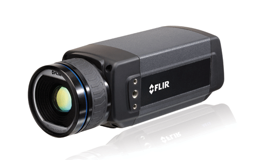
ING will mount a FLIR A6700sc infrared camera to its Responder drones. PHOTO: FLIR SYSTEMS
The A6700sc cameras onboard the Responder drones produce temperature-calibrated infrared imagery for research and science applications. It detects temperature changes with a sensitivity of 0.02 degrees C and is able to measure temperatures down to 15 um per pixel. Featuring a highly sensitive 640 x 512 pixel resolution detector, the camera’s image output can be windowed to increase frame rates to 480 frames per second to accurately characterize high-speed thermal events.
“After the flight, all that data is recorded, and we can see the temperature in each pixel,” says Vidal. “In the oil and gas industry, heat detection is a big thing, and we’re able to see hot spots where there shouldn’t be hot spots.”
Talk about staying on top of environmental and safety performance.
About ING, flir
Founded in 2002, ING Robotic Aviation developed its reputation in the UAV industry through extensive operational surveillance work with the Canadian military. The company has since provided more than 30,000 hours of unmanned aerial surveillance services in Afghanistan to military operations there, and has an ongoing presence onboard a Canadian warship in the Arabian Gulf.
FLIR, founded in 1978, has grown to become the world’s largest manufacturer of infrared imaging systems and now has more than 3,200 employees with sales topping $1.4 billion in more than 100 countries.